Wednesday, November 7, 2018

What is the Sopris Challenge?


The Sopris Challenge. Ever heard of it?

I’d tried it once before. Arriving at the top of the extremely loose, scree-covered false summit of Mount Sopris, I found I shared the resting spot with a couple of teenage hikers. They asked when and where I had started.

I pointed toward the town of Carbondale, at the valley floor. “Town, at 6 this morning.”

“Why would you do that? Want a candy bar?”


I told them it I did want a candy bar, and that I was doing the Sopris Challenge.

“Never heard of it.”

I ate the proffered candy bar as I explained the challenge to them. Their unfiltered reactions pulled on the strings of my reason, eventually mutating into the action of turning around a mile shy of reaching the true summit. A decision that would nag at me for the next 8 years.

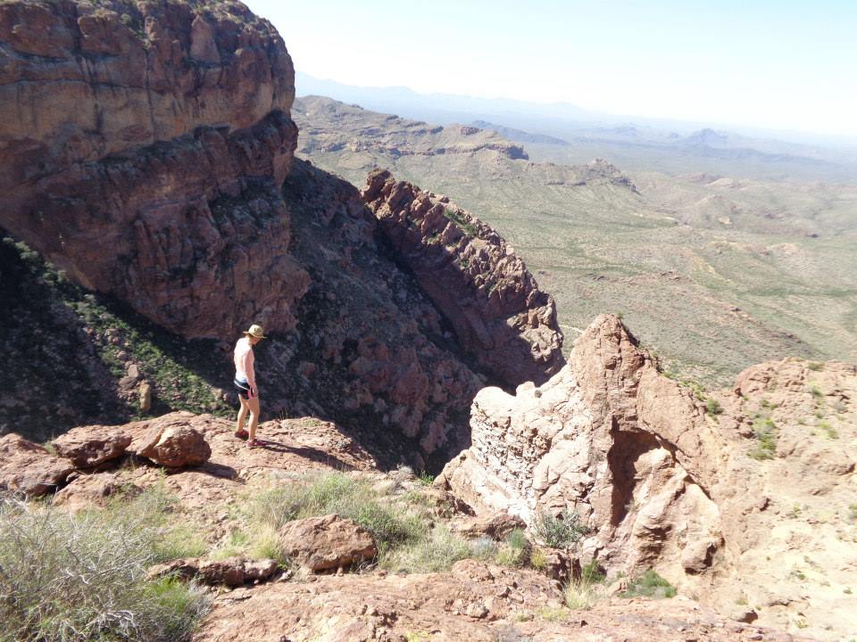
Mount Sopris is the Mona Lisa of mountains. No matter where you stand in the Roaring Fork Valley, high or low, the mountain’s gaze is always on you. 10 years ago, freshly arrived to the town of Carbondale, CO, I was working a shift at the local running shop when the owner, Brion After, started in about the Sopris Challenge -- a run from town, sitting at an elevation of 6,181 ft to the summit, standing at 12,953 ft. After explaining it to me, I asked him for more details. Who’s done it? How long is it? What do people cover that distance in? He had no answers.

In recent years, many locals have created an annual Sopris Challenge combining biking, skinning and skiing. I’ve even heard of a few locals creating a challenge comprised of biking, hiking, and then floating the river back down to town. But no one seemed dumb enough to run the damn thing.


8 years after my last attempt, I find myself sitting on the false summit again thinking about turning around. Knowing I might again succumb to the temptation of turning back early, I recruited the help of two friends to pace me through the mountain section of the run.  My good friend Morgan Neely met me 11 miles in at the Thomas Lakes Trailhead in order to ensure I made it to the summit of Sopris. I watch as he climbs up the rise and sits down beside me.

“Last time I turned around here….do you have a candy bar?”

“I’ve got a coke you can have, but I’m not giving it to you unless you make the summit.”

The summit is a long, slow grind and another 40+ minutes round trip back to the false summit. The ridge is anything but fast, comprised of mostly un-runnable, loose talus fields and craggy ledges. At the summit, I have roughly 7,000 ft in 17-18 miles in the bank and nowhere to go but back down. Looking down the ridge toward home, I start feeling a euphoria about possibly accomplishing something I’d previously failed.

Leaving the summit and beginning our downward trajectory, I keep an eye out for my friend Jeff Stephens, who has promised to meet up with us at the false summit to pace me back to the trailhead. After scree-surfing the last pitch to tree line, we are met with the sound of George Michael blasting from lower on the trail. Soon we run into the source-- Stephens laying sprawled on the tundra with his iPhone on his chest. He pops up and immediately sets a hard lead pace that I lock onto.

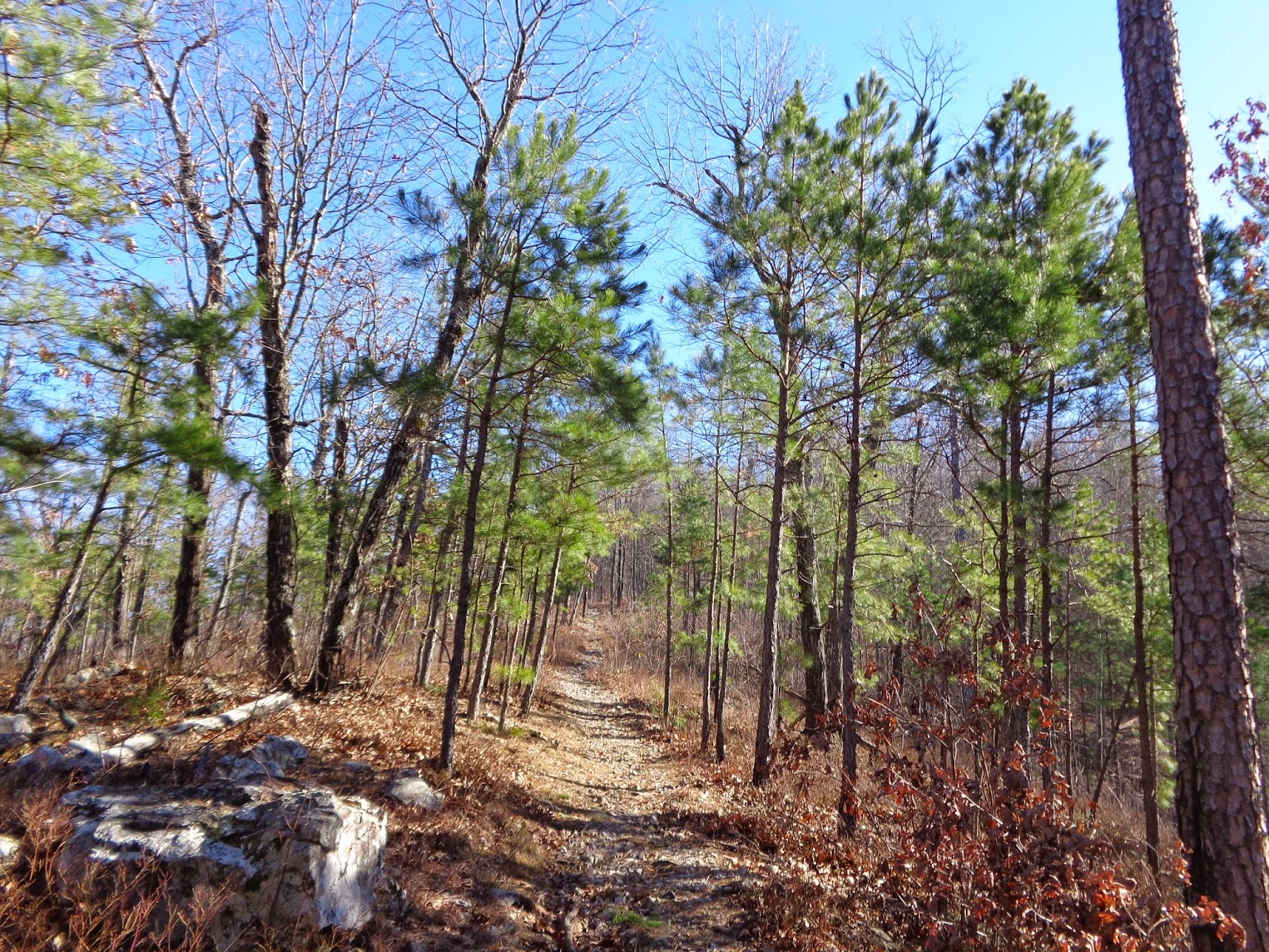
With Sopris behind, Stephens and Neely leave me to the solitary task of the final 11 miles. This last leg of the challenge is exposed dirt road and pavement back to town. The cumulative fatigue of pounding nearly 7,000 ft downhill starts to take its toll along with the 95 degree heat and I suffer a meltdown 2 miles from the end. Hopping a fence to lay down in a farmer’s field among his water sprinklers, I look up to the heavens and promise myself I’ll never do this again.

I round the final turn and see Sopris Park and a makeshift finish line of caution tape and votive candles. Neely, Stephens, and my pal Jeff Colt cheer me in along with a bunch of park workers.

After blasting me with silly string, Morgan points to the workers, “That’s the Town of Carbondale Public Works Department.”

“Parks and Rec! We’re Parks and Rec!”

Jeff Colt congratulates me and then follows up with, “I’ve never heard of the Sopris Challenge”.

Apparently he wasn’t alone. Neither had the Parks and Rec Department. No one I’ve told since has any clue what I am talking about when I tell them I ran the Sopris Challenge…..I’m beginning to think Brion was trying to pull some sadistic joke on me. Is this challenge even a thing?


_________________________________________

*The Sopris Challenge starts at Sopris Park in Carbondale, CO. Take whatever roads you want out of town to the Prince Creek turnoff. Take either the road or Prince Creek Trail to the Thomas Lakes Trailhead. Take the trail to the first real summit of Mount Sopris and then repeat your route back to the park. It is roughly 36 miles and 7,000~ ft of gain.


Thursday, November 12, 2015

Ten Flavors of Icing

As 2015 draws ever closer to an end, I thought it might be time to look back on some of my favorite runs from this last year. 2015 was fully about my marriage to my best friend Lyssa and anything else was just icing on the cake. Below are 10 flavors of icing.


Exploring the Little Book Cliffs --
The Little Book Cliffs is a preserve and wilderness study area for wild horses. The trails of this massive, untapped area are just outside of Palisade, CO and get very little traffic. I first "discovered" this area 3 years ago, and have made it a tradition to explore the region each winter. Each time I've visited the Books Cliffs, I've gone along with my good buddy Casey Weaver. We have made 5 or 6 good runs of these trails and have yet to successfully connect a loop. It's always fun to have a herd of wild horses run right by you while navigating 20 creek crossings in a 5 mile stretch.

Casey charging down from a plateau in the Book Cliffs


Perham Trailhead to Lorax Trailhead--
A few years ago I started piecing together an idea of connecting 3 different trail systems just outside of Carbondale into a larger point-to-point run. Starting at the Perham Trailhead 15 minutes up the road from town, a group of us ran the Perham Trail up and into the Thompson Divide area. From there we were able to run an old railroad grade up to rancher roads that eventually allowed us access to the backside of the Lorax Trail system. It was very aesthetic to finally piece together these 3 trail systems.

Following Casey Weaver and Michael Barlow into the Lorax


Marion Gulch to Sunlight (and back)--
This ended up being one of my favorite runs of the year, mostly because I had dreamed about it for so long. Marion Gulch is a trail system that gets the most play from snow-mobile traffic in the winter. These trails supposedly provide a path all the way to the Powderhorn Ski area on the Grand Mesa some 100+ miles away. A few of us had often talked about running Marion over to the Sunlight Ski area in Glenwood Springs and back. A group of us decided to go for it one day and were very pleased once we got onto the deck at the top of the Sunlight Ski hill 90 minutes later.

The Elk Mountain Runners on Top of Sunlight


Trails of Organ Pipe Cactus National Park--
My wife and I try to take one road trip a year. For 2015, we decided to take a spring trip to a very obscure National Park on the border of Arizona and Mexico. We found ourselves in the Organ Pipe Cactus National Park, an extreme landscape littered with signs warning against "illegal" activity in the area. The trails were absolutely amazing and mostly "vacant" of hikers, the air was littered with patrol helicopters, and at one border check we were asked if we were hiding someone in a 2x2 cooler.

Lyssa looking down from one of the trails in the park


Hermit Trail--
The Grand Canyon is a magical place, and also a trail running playground of magnificent scope. Beyond the main corridor exists countless other trails that sit off the radar. I ran one of those trails at the end of our annual road trip this last spring. The Hermit trail runs from the rim of the canyon down to the rapid of the same name at the bottom of the canyon. The reverse experience of running over 4,000 ft down first was unique and painful on the return.

Toward the top of the Hermit Trail


Tabeguache to Shavano--
Enter the bachelor party. Zeke Tiernan, Jeason Murphy and Adam Flatt gave me a great send-off with an epic loop up the backside of the 14'er Tabeguache and then over to Shavano before descending off the front and back to our campsite. All told it was 5 hours of running, 3 great friends, 2 14'ers, 1 massive hangover, and countless fun.

Jeason Murphy, Zeke Tiernan, myself and Adam Flatt on Savano


Alta Via 1 Trail--
The Alta Via 1 trail is a through-hike in the Italian Dolomites near the Austrian border. Lyssa and I decided to hike this route for our honeymoon. Lyssa once again proved her superior intelligence as she brought trekking poles for this amazingly steep trail, while I hiked along sans-poles in envy. 

Lyssa "Honeymooning"


Mount Sopris Ridge--
Finally running the ridge line from Hell Roaring up to Mount Sopris was another marque run for me late this summer. I look up at Mount Sopris every day, and have always dreamed of summiting the mountain from it's non-traditional backside ridge. Finally running from the Haypark Trails parking lot near Capitol Trailhead up Hell Roaring and across to the summit of Sopris was a journey I undertook alone. Descending off the front and returning to my car via the Haypark Trails made for an atheistic outing I hope to repeat with friends next year.

(The Ridge Line up to Sopris. I was camera-less on this run, so I ripped this pic from Zeke's blog)


Conundrum - Triangle Pass - East Maroon--
This was my last big run of the year. This 22-ish mile loop is an absolute must-do classic and a favorite of the locals that frequent the Elk Mountains, and yet I had never run this particular loop. After hearing about this run for years, it was great to finally check it off the list, and great fun to have Casey Weaver as my guide. Even though my body was taxed and aching for a break by this point, I was glad to squeeze in one last major outing before the high country closed up.

Blowing up on Triangle Pass


Elk Mountains Super Loop--
This was the biggie. Every year my wife takes her students on a week-long Outdoor Education backpacking trip. As has become customary, I plan a route to run out to meet her and the kids. This year I decided to make my visit en-route to running the "Super Loop", a 40-ish mile run with 11,000-ish feet of climbing. Ted Mahon coined the phrase for this loop. Read about it at "Stuck in the Rockies". Also read about Zeke Tiernan's outing of the "Super Loop" here. This is one of the greatest tours of the mountains the Roaring Fork Valley has to offer and a loop I will do again. On this particular day, Casey Weaver and I saw every Outdoor Ed group but my wife's, so I left tootsie pops in a heart shape on the trail for her. Hikers would later find the tootsies and tell my wife about them. Casey proved to himself that he could handily run for 40 miles, but that he could also delete all the pictures he took of the run. I proved to myself that I'm a bozo for mis-judging where I would see Lyssa. It was 10 hours of great fun. Maybe we should rename it the "Super Hoot".


Tuesday, September 8, 2015

Keeping the Right Perspective

Lyssa and I are driving down to Creede for the annual Labor Day celebration, which kicks off with a mountain run around Creede's "bachelor loop" on Saturday morning. I tell her I'd like to do well tomorrow. She tells me she wants a puppy. My wife Lyssa is my best friend, and as such is also the best equipped at making sure I stay in the right frame of mind. In the end, no one is going to care. Do it for yourself, because you want to. Results don't matter in the end.

 ……………...

I cross the finish line at the Creede Mountain Run in 3 hours and 11 minutes. Immediately, a man walks over and tells me he has gone sub 3:10…but the record was set in 1988…an oil man from Oklahoma put up money for the winner. "Wanted this race to be as big as Pikes Peak!" A bunch of Kenyans came out of the woodwork and one ran a 2:55…"but that's not the record in my mind." This guy came out in the early 90's and "ran a 2:58, after getting lost!"…Obviously, results don't matter. No one knew what the record really was…I found myself wanting a puppy.

  …………….

Two days later, at the campground just outside of Creede, I'm reclining in a chair watching the sun slowly rise.

"Well? How is it go'in for you this morn'in?"

I lift the brim of my hat off my eyes and look up at a dead-wringer for Damon Herriman's Dewey Crowe. He is standing next to me looking out at the rising ball of light.

"Yessir, I ain't like'in this cold weather. Caint wait for it to warm up a bit. COME'ON SUN!"

I ask my new friend where he hails from.

"Fill in the blank, Texas", he says. "We come out here every year". Lyssa comes over and sits in the chair next to me as we enter into a 40-minute-long conversation with our mystery Texan.

Spint two seasons on a fishing boat up in Alaska… fish'in for Swordfish. Out on that Bearin' Straight.
Mechanic, just helping folks out where they need it. Helped out a gal in Alamosa just tryin' to get back on 'er feet. Been here. Done this. You should go there. I'm amazed at all this man has experienced. Tells us how he is immune to poison sumac, ivy…"'cause his grandfather gave him a special Cherokee potion when he was little. The Cherokee knew things we'll never know."

Lyssa tells him we just ran a race around the Bachelor Loop.

"Run?! What fer when you can drive it?!" He says, at one point telling me I'm to scrawny, just like him, to be running too much. He lifts his oversized flannel up for emphasis, showing us a tattoo of a Hula Girl laying across his mid-drift.

He scratches the scruff of his chin. "Well. I think it might be time fer some coffee at my camp. It certainly has been a pleasure. You folks take care."

I do like Creede.


Last Turn at the CMR

Lyssa cruising to the finish

Wednesday, April 1, 2015

Grand Canyon - Hermit Trail Trip Report

Two summers ago, I had the privilege of experiencing the Grand Canyon by raft. My river trip that summer began at Phantom Ranch and the first major rapid of the day was a roller coaster of water called Hermit. The hydraulics of the river along with the wildness of the canyon left me in awe. As we floated along, I found myself continuing to glance up at the rim. I was overcome with curiosity about the trails that would allow access from the rim. For as long as I've been a runner - road, trail, ultra or otherwise - the canyon has always stood as an "ultimate experience" for runners. And my desire to experience a run that stands in contrast to mountain running in every way further interested me.

I recently finished Kevin Fedarko's "The Emerald Mile", an amazing account of the legendary 1983 speed run of the Colorado river in a dory. I finished the read just as Lyssa and I were preparing to go on our annual road trip and the book had done it's job of renewing my curiosity, so last week Lyssa and I spent the last few days of our annual trip at the "big ditch". After some research, I discovered that there was a lesser used trail that traveled from the south rim down to the river, ending at that very first major rapid, Hermit, that I experienced a few years ago. Aptly named the Hermit Trail, the excursion takes you down 4,200-ish ft in 9-ish miles to the river.

From March 1 to October 31, the only way to get to the trail head is by tour bus, so Lyssa and I hopped on and enjoyed the 40 minute tour to the end of the Hermit's Rest road where the trail begins. After telling Lyssa how long to give me before worrying, I headed down the trail and immediately realized I misjudged how long the run was going to take me.

For everyone's future knowledge, the Hermit Trail is not a fast, buffed out single track. It is not Bright Angel, or even the Kaibab Trails. It is true, rad single track covered with tons of talus, loose volcanic rock and very steep stone steps. The trail also has a very curious flow to it. After the initial drop of what I'm guessing is 1,000-ish ft, the route levels off and moves along a shelf for some miles before dropping again. The biggest drop starts a little over 5 miles in at Cathedral Stairs (which is very steep and very loose), where you plummet 2,000 ft down to the river. The last few miles are through a wash that eventually drains into the Colorado.

I took my time on the way down, soaking in the views and chatting with a few groups of hikers that had camped at the canyon floor the night before. After tagging the rapid, I turned around and blew up hard. The canyon punched me right in the face. As it turns out, it's pretty hard to run downhill for a long time first. I just tried to enjoy the ride and was really happy when I finally made it back up to the rim. Surprisingly, the upward journey only took me 20 minutes longer than the run downward, for a total time of 4 hours and 21 minutes of "happy time".

The truth is that the canyon is chalk full of lesser-used routes begging to be explored. Just remember to give the canyon the respect it deserves as you play among it's shelves.


Friday, March 13, 2015

To Trudge...


"Trudging…To trudge: the slow, weary, depressing yet determined walk of a man who has nothing left in life except the impuse to simply soldier on" -Paul Bettany as Geoffrey Chaucer, A Knight's Tale, 2001.

A few weekends ago I found myself in Laramie, Wy for the 11th annual Twin Mountain Trudge. A quick visit to Alec Muthig's Journeyman Adventures webpage offers a glimpse at a "race" that is not only tough, but a little terrifying. All the research I'd done on the race beforehand only verified that it was indeed "as difficult as advertised" and "a punch in the face".

A quick breakdown of this event looks something like this: Free entry for the first 60 folks to sign-up with no wait list. You must carry recommended survival gear on your person for either an 11 mile single or 22 mile double loop. The course runs through the Medicine Bow-Routt National Forest along the Twin Mountain massif through conditions that vary year to year. With a bottle of whiskey set at the half-way point of the loop, the only other aid you receive is at the start-finish area. 

This race has a sort of "underground, mini winter version of Barkley" feel, and wanting to finish two loops, I held back as much as I could on the first round. After getting lost for about 5 to 10 minutes by making a left that wasn't right, and having the hose of my hydration pack freeze up, making it hard to stay hydrated on the first loop, I finished up round one a little out of it. 

I took a few minutes to regroup, changing my shirt and jacket and switching out my pack for two hand-held water bottles. Lyssa dealt with "grumpy Jeremy" like a pro, and sent me on my way for round two, which went much more smoothly. I used the first 30 minutes to eat a few bars and drink most of one of my bottles. I found my mood lift and before I knew it I was heading up the last hill to Alec Muthig holding an ice-shot glass full of whiskey. I finished the second loop, took the customary shot, then went behind the car to die.

This is a great, low-key running challenge with top notch organization that you don't always see at larger events. It was refreshing to see Laramie's close-nit group of trail runners and I enjoyed chatting with them before and after the run. And yes, it is as hard as advertised. It's just good ole-fashioned suffering and I'll be excited to trudge again.


Tools of the day:
Brunton Compass (Christmas gift from soon to be mother-in-law)
Map (from the registration table)
Scarpa Spark Goretex shoes
Salomon Hydration Pack (1st loop)
Lightweight Nathan Pack (2nd loop)
Obermeyer Buff
Pearl Izumi Jacket (1st loop)
Patagonia Jacket (2nd loop)
2 Pairs Smartwool Socks
Space Blanket
Lighter
A really loud whistle
Pearl Izumi running gloves
Smart Wool base layer (1st loop)
Ibex wool base layer (2nd loop)
OR mini-gaiters
A long sleeve shirt from a race a long time ago
Running tights…duh
a red beard
lots of cliff bars and Gu
probs some other things that I have forgotten

photos courtesy of Journeyman Adventures


Tuesday, February 10, 2015

Ultimate Cross-Training

Deep in the bowels of winter in our pocket of Colorado's Western Slope, few trails remain open from December through March, or at the very least are in great running shape. Cross-training and road running fill the void left by lack of great dirt trails and mountain miles.

Winter is a great time to slacken the amount of miles and time run and pursue other means of maintaining fitness. Swimming, cross-country skiing, snowshoeing, and alpine skiing are great ways to lessen the impact from running and switch it up. However, I have found the ultimate cross-training during these dark winter months to be Swiss-bobbing.

Equipped with small butt sleds known as "Swiss-Bobs", or as our versions are called "Merikan Missiles", we are able to get in a good uphill hike on one of our local ski hills and then come screaming down in 5 to 15 minutes.

When coming downhill at 25 to 30 miles an hour, please remember to wear a helmet and steer clear of trees, lift poles, warming huts, and other people. Be advised that screams leaving your mouth from pure joy not experienced since your youth are sure to happen.


Tuesday, December 2, 2014

Looking Back On 2014

In the summer of 2006 I remember having a conversation with my former high school cross country coach. He told me that I was a "lifer" in regards to my running.

Somewhere along the way I translated that conversation's meaning into "run as many trails and see as many things as you can before you die." As 2014 draws to a close, it's fun to look back on the year and reminisce about some of the trails I was lucky enough to experience. Here are a few of my favorites from 2014.

Tall Grass Praire Preserve Trails - The trails of this National Preserve near Wichita, Kansas equal about 40 miles in all. I did a 10 mile loop on January 1st of this year. Running in a sea of grassy sameness was unique and stood out to me as a wild experience.

Running on the Prairie


Winding Stair Mountain - The trails throughout the Ouachita Mountains on the border of Oklahoma and Arkansas are an amazing, under appreciated playground for trail running, but my favorite trail thus far explored has to be the trail on Winding Stair Mountain. The single track exists on the Oklahoma side not far from Talimena. I ran this trail on the last day of Lyssa and my annual road trip at the beginning of the year.

Toward top of Winding Stair Mountain


Rattlesnake Arch Loop - This is an 18-ish mile route that sits in the McInnis Canyon National Conservation Area outside of Fruita, Colorado. I ran this early in the year with Casey Weaver and Corey Dobson. This route offers the best arches outside of Moab. On the back half of the loop, we climbed up and through the largest of the arches before looping back around to the car.


FairyLand Loop - This is an 8.5-ish mile loop in Bryce Canyon National Park. If you are going to run one trail in the park, make it this trail. The loop starts on the rim and drops into a forest of ponderosa pine and bizarre hoodoos. The range of color was mind-blowing and the loop had a great flow to it.

Running halfway through Fairyland Loop


Thompson Creek Lake Ridge Lakes Loop - This was my favorite run of the year. Casey Weaver, Morgan Williams and I did a bulk of our training together this year. Our early season runs took us into the Thompson Divide area just above Carbondale, Colorado, for some extremely wild outings. My favorite of these was a 16-ish mile run to a very secluded trail, Lake Ridge Lakes.

Elk Mountain - I've done this run the last 3 years in a row, and next year I hope to make it 4 in a row. It's a great and very hard 12 to 14 mile run. It's a classic mountain outing that punches your ticket. 4,500 of climbing in 6 miles and then back down. Route finding is key on this run.

Casey and Morgan on the first false summit en route to Elk


Mount Massive - This year I was able to knock 4 more 14er's off the bucket list. My first of the year was Mount Massive. Lyssa and I camped out at the trail head outside of Leadville, Colorado and bagged both summits of Mount Massive the next day. This was a great weekend trip with Lyssa a few weeks after proposing.

Lyssa and I on Top of Massive


Sugarloaf Mountain - This run was only 3.5ish miles…maybe. But the trail head was virtually a local secret. Finding the thing was a trick in itself. The route was only 1.5-ish miles one way, starting at the beach and climbing steeply to the summit of Sugarloaf 17 painful minutes later. The view at the top was wild. It was pretty special to swim in the ocean immediately following the run.

running up Sugarloaf

Top of Sugarloaf


Cabot Trail - This is the designated route that circumnavigates the perimeter of the upper peninsula of Nova Scotia. Lyssa and I bike toured the 300-ish kilometer route this summer and explored the cape in all it's glory. This was my favorite experience of the summer.

Lyssa flying downhill on the Cabot Trail


Franey Trail - This is an 8-ish mile loop within the Cape Breton Highlands National Park in Nova Scotia. A local told us that this was "THE" trail to do. I ran this trail once clockwise, then turned and ran it back in reverse. The trail had highly exposed roots, tons of stair steps and was extremely wet. I had a hoot.
Top of Fray


Tired Shoes